Welcome to our website and cycling club. Club membership is open to all! Whether you're a racer, recreation rider, or just starting out, the Sierra Foothills Cycling Club wants you! Get to know more about our club in our FAQ, or drop us a line from our contacts list.
Our Mission
Our club's mission is to share our passion for bicycle riding through organized events, including a variety of weekly rides designed for both novice and experienced bicyclists of all ages.
Our Rides
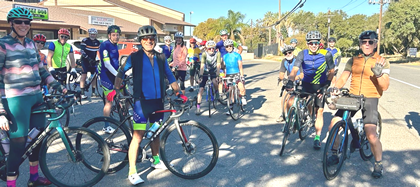
Our group bike rides traverse the beautiful foothills of the Sierras in and around the city of Auburn. For more information about our rides visit: ride info. Join us to explore the area while having fun, getting fit, and meeting fellow cyclists.
Join me for a fall favorite visiting some of the best of the fall colors in the Maidu area. Only 17.2 miles but some good climbing for a good workout. Get it in while we have this great weather.
Coffee afterwards at North Fork Chai Co.
Route Cue Sheet --------------------------------------------- Follow the Fall Colors 2 -- 17.2 miles 3.7 Left -- Rattlesnake Rd 5.3 Left -- Shirland Tract Rd 5.3 Right -- Auburn Folsom Rd 6.0 Right -- Tyler Dr 6.3 Left -- Ridgeview Cir 6.7 Right -- Sunrise Ridge Cir 8.0 Right -- Auburn Folsom Rd 8.6 Right -- Southridge Dr 8.7 Left -- Grayhorse Dr 8.8 Right -- Shirland Tract Rd 9.0 Left -- Rosemary Dr 9.3 Left -- Burlin Way 9.5 Right -- Perkins Way 9.6 Right -- Vista Del Monte 9.7 Cont -- Vista Del Lago 10.1 Cont -- Mary Jane Ct 10.1 Right -- Poet Smith Dr 10.4 Left -- Carolyn St 10.4 Right -- Ginger Dr 10.6 Left -- Herrington Dr 10.7 Right -- Valley View Dr 10.7 Left -- Skyridge Dr 10.8 Right -- Sacramento St 10.8 Make a U-turn at Valley View Dr 11.4 Left -- Auburn Folsom Rd/Sacramento St 13.9 Right -- Powerhouse Rd 14.0 Right -- Vista Cielo Dr 14.9 Left and becomes Vista Amado Ct 15.1 Left - Unmarked road 15.3 Cont -- Happy Hollow Ln 15.7 Right -- Powerhouse Rd 16.7 Right -- Newcastle Rd Leader Cell:
Pre-Turkey Day calorie burn from Auburn Baked & Brewed Cafe. A short-ish ride from downtown Auburn in the direction of Christian Valley, across Hwy 49 on Dry Creek and returning home on Mt Vernon and Millertown. There's a potty break scheduled at the real restrooms in the regional park on Richardson/Dry Creek.
Post ride coffee and conversation at Baked & Brewed Cafe.
Please print your own route sheets.
Route Cue Sheet --------------------------------------------- Auburn Loop (Baked&Brewed1) -- 31.9 miles 0.0 Left -- High Street 0.1 Right -- Lincoln Way 0.5 Right -- El Dorado Street, CA 49 0.6 Left -- Lincoln Way 0.6 Right -- Aeolia Drive 1.4 Right -- Foresthill Avenue 1.4 Right -- Foresthill Avenue 1.6 Right -- Foresthill Avenue 2.0 Left -- Russell Road 2.3 Keep Left -- Russell Road 2.5 Left -- Russell Road 2.5 Right -- Lincoln Way 3.9 Left -- Bowman Undercrossing Road 4.0 Right -- Bowman Road 6.0 Right -- Dry Creek Road 6.8 Right -- Lake Arthur Road 7.3 Left -- Pinewood Way 7.8 Left -- Bancroft Road 8.9 Right -- Christian Valley Road 11.2 Left -- Stanley Drive 12.2 Left -- Virginia Drive 12.7 Right -- Moss Rock Drive 13.9 Right -- Blue Grass Drive 14.0 Right -- Dry Creek Road 15.3 Left -- Richardson Drive 15.7 Make a U-turn -- Richardson Drive 16.1 Left -- Dry Creek Road 16.8 Left -- Joeger Road 18.6 Left -- Mount Vernon Road 19.1 Keep Right 19.2 Right -- Mount Vernon Road 21.5 Right -- Millertown Road 22.3 Keep Left -- Millertown Road 23.8 Left -- Wise Road 24.4 Right 24.4 Right -- Ophir Road 26.3 Right -- Taylor Road, CA 193 26.7 Left -- Old State Highway, CA 193 26.7 Keep Left -- Old State Highway 27.0 Left -- Newcastle Road 27.1 Left -- Indian Hill Road 29.5 Left -- Auburn Folsom Road 30.1 Right -- Sacramento Street 30.6 Right -- Pacific Avenue 31.6 Right -- High Street 31.9 Left -- Lincoln Way Leader Cell:
Thursday rides are hilly, shorter, more casually paced rides (usually around 20 miles with approximately 1800 feet of climb). Ride is swept and everyone more or less stays fairly close together. There are also numerous regroups on this ride. Currently, this ride is out of Meadow Vista Park in Meadow Vista. The last Thursday of the month starts out at Railhead Park in Auburn.
The rides usually start at Meadow Vista Park. However, check the calendar for occasional changes to the start location.
Ride Description and Notes: Please join me in a post-Thanksgiving ride to burn off some of that delicious food and pie! We'll start with some climbing up Rock Springs/Newcastle Rd/Indian Hill and come down Millertown to Chili Hill. Climb up and over Ridge and finish back at Penryn Park and Ride. Coffee and conversation at Roanie's afterwards.
Please print or download the route. Friday All-Pace rides do not typically have a sweep.
Route Cue Sheet --------------------------------------------- PPR Double Climb -- 28.0 miles 0.1 Right -- Penryn Road 0.3 Left -- Boulder Creek Road 0.3 Right -- Boulder Creek Road 1.3 Right -- Aspen Drive 2.6 Left -- Brennans Rd 3.8 Left -- Newcastle Rd 5.2 Right -- Indian Hill Rd 7.6 Left -- Auburn Folsom Rd 8.2 Right -- Sacramento St 8.8 Right -- Pacific Ave 9.4 Cont -- Pleasant Ave 9.8 Left -- High St 9.9 Right -- Auburn Folsom Rd 10.3 Cont -- Maple St 10.4 Left -- Placer St 10.5 Right -- Nevada St 11.2 Left -- Enterprise Dr 11.4 Left -- Mt Vernon Rd 12.1 Left -- Millertown Rd 12.9 Left to stay on Millertown Rd 14.4 Right -- Wise Rd 15.3 Left -- Bald Hill Rd 15.7 Right to stay on Bald Hill Rd 15.8 Cont -- Chili Hill Rd 19.4 Cont straight -- Gold Hill Rd 20.2 Left -- Ridge Rd 23.7 Right -- CA-193 W 26.6 Right -- English Colony Way 26.7 Left -- Penryn Rd 27.2 Right -- Taylor Rd 27.2 Left -- Penryn Rd 27.9 Right -- Boyington Rd Leader Cell:
Saturday - Rocklin thru the Back Door Sat, Nov 29, 9:00am 0 comments
Ride Description and Notes: Saturday will be a beautiful day to ride up, down and around the foothills. The route takes us from Penryn up to Newcastle, down the Butler rollers, over to 12 Bridges and through the back door to Whitney Ranch Parkway. Climb Park Drive and then kick back on the last 8 miles through Rocklin into Loomis.
Route Cue Sheet --------------------------------------------- Rocklin thru the Back Door -- 26.9 miles 0.1 Left -- Penryn Road 0.7 Right -- Taylor Road 1.2 Right -- Rock Springs Road 1.8 Left -- Gilardi Road 2.4 Right -- Gilardi Road 3.6 Left -- Newcastle Road 5.1 Left -- Old State Highway 5.1 Right -- Old State Highway 5.4 Left -- Taylor Road 6.4 Right -- Callison Road 7.7 Keep Right -- Callison Road 7.7 Right -- Clark Tunnel Road 8.0 Left -- Gold Rush Way 8.7 Right -- Butler Road 9.1 Keep Left -- Butler Road 9.4 Keep Left -- Butler Road 10.1 Left -- Butler Road 10.9 Right -- English Colony Way 12.2 Right -- Sierra College Boulevard 13.0 Left -- Twelve Bridges Drive 14.3 Left -- Twelve Bridges Drive 15.3 Left -- Ridgecrest Drive 16.0 Left -- Nisenan Valley Drive 16.5 Right -- Whitney Ranch Parkway 16.7 Left -- Whitney Oaks Drive 18.0 Cont 18.0 Left -- Park Drive 18.3 Right -- Crest Drive 18.5 Right 18.5 Left 18.8 Right 18.8 Right -- Crest Drive 20.1 Left -- Whitney Boulevard 20.4 Keep Right -- Whitney Boulevard 20.6 Left -- Midas Avenue 22.3 Left -- Pacific Street 25.4 Right -- King Road 25.9 Left -- Boyington Road Leader Cell:
Sunday - Granite Bay - Lincoln Double Loop 41miles/2484 climb Sun, Nov 30, 9:00am 0 comments
Ride Description and Notes: This Sunday, ride from Griffith Quarry, out to McBean. 41 miles, 2500'. Print route sheet if you need one. Hopefully, fog isn't present. Roger
Route Cue Sheet --------------------------------------------- Granite Bay - Lincoln Double Loop 41miles/2484 climb -- 41.3 miles 0.0 Right -- Rock Springs Road 1.9 Right -- Brennans Road 3.1 Left -- King Road 3.2 Right -- Auburn Folsom Road 8.1 Right -- Cavitt Stallman Road 9.8 Right -- Barton Road 11.4 Right -- Rutherford Canyon Road 12.7 Right -- Laird Road 13.5 Left -- Wells Avenue 13.7 Wells becomes Val Verde 16.5 Left -- King Road 16.8 Right -- Penryn Road 18.1 Right -- Taylor Road 18.6 Left -- English Colony Way 22.1 Right -- Sierra College Boulevard 22.9 Left -- Twelve Bridges Drive 24.1 Right -- Stoneridge Boulevard 25.2 Right -- Del Webb Boulevard 25.4 Right -- Sun City Boulevard 26.7 Right -- Ferrari Ranch Road 27.2 Left -- McBean Park Drive 27.4 Left into McBean Park REST STOP 27.6 Right -- McBean Park Drive 27.6 Left -- East Avenue 28.1 Right -- East 9th Street 28.6 Keep Left -- Liberty Lane 28.8 Right -- Virginiatown Road 32.1 Left -- Fowler Road 32.1 Right -- Virginiatown Road 34.3 Right -- Gold Hill Road 34.9 Left -- Ridge Road 38.5 Right -- Taylor Road 41.3 Left -- Rock Springs Road 41.3 Right into quarry DONE Leader Cell:
Tuesday RideTue, Dec 2, 9:00am 0 comments
Where: Newcastle Park and Ride Newcastle, CA (map)
Tuesday rides are variable, depending on who leads and who shows up. Generally, the climbing is 1500-2500 feet, and the distance is 18-25 miles. Oftentimes, there are no regroups due to the short distances offered. This ride's start location is currently at the Newcastle Park & Ride.
Coffee and conversation afterward at Newcastle Produce.
Wednesday rides are the most aggressive rides of the week (26-40 miles) and are fairly hilly. Currently, this ride usually starts out of Meadow Vista Park in Meadow Vista. However, always check the calendar for a different start location.
Thursday rides are hilly, shorter, more casually paced rides (usually around 20 miles with approximately 1800 feet of climb). Ride is swept and everyone more or less stays fairly close together. There are also numerous regroups on this ride. Currently, this ride is out of Meadow Vista Park in Meadow Vista. The last Thursday of the month starts out at Railhead Park in Auburn.
The rides usually start at Meadow Vista Park. However, check the calendar for occasional changes to the start location.
All pace ride. Riders ride at their own pace or form groups riding a similar pace. Often times, there are no regroups due to the short distances offered. Approximately 25 miles. No sweep.
The Saturday ride USUALLY meets at PENYN PARK AND RIDE.
There is an A group and a B group. The groups can spread out then you can ride your own pace...usually two or three groups with pairs scattered about and some single riders too.
The ride ranges between 25-30 mi with 1500k- 2000k ft of climbing.
Sunday rides are at least 40 miles in length, giving moderate level riders the chance to ride a little further than our average distance. You'll find some rides that are flattish and some that are killer hilly. The average pace of the Sunday rides varies hugely based on the distance and the amount of climb. The start location of this ride varies weekly, so check the calendar.
Save the date for the 2025 SFCC Holiday Mixer to be held at Victory Velo Bike Shop. What to bring? An appetizer or a dessert . Think finger foods. Your club will provide water and sodas, cups, plates, and napkins. You may bring your favorite wine or spirit.
Ever wondered what inspired our past and present SFCC jersey designs? Watch the following video to find out...and as usual, you'll find there's always more to the story.
For more videos of SFCC rides and events, visit and subscribe to the SFCC YouTube Channel
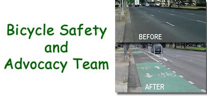
The SFCC does more than just ride around the foothills...we work to improve the riding safety and convenience for all riders in the area. Members of our club have formed a safety and advocacy team working with Placer County to improve the cycling infrastructure and ensure future development includes bicycle friendly features. Read more about our team's current projects and accomplishments and if you are interested in sharing your vision for a fun and safe cycling community.